Bānposh night lights from space
Night Light of Bānposh (Odisha) from space (India) Src. Average luminocity for 10x10km area is 78.7538% and for 50x50km: 14.5492%.
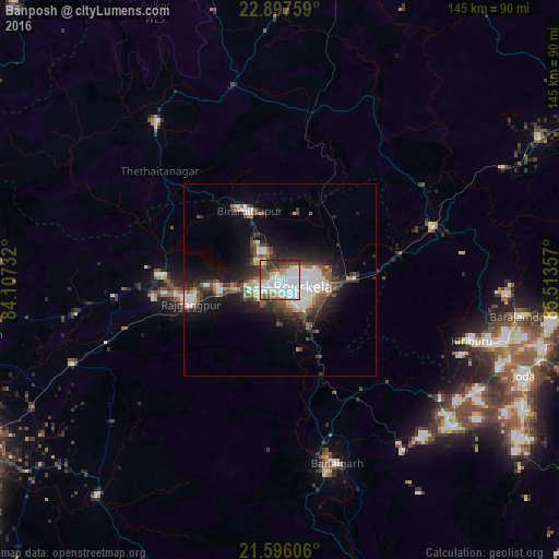
Analysis of Bānposh night lights 2016
Square area 10x10 km:
 38.07%
90-99
17.99%80-89
6.63%70-79
2.46%60-69
4.36%50-59
9.09%40-49
10.42%30-39
8.14%20-29
2.84%10-19
0%0-9
0%Square area 50x50 km:
3.71%90-99
2.58%80-89
1.04%70-79
0.77%60-69
1.2%50-59
2.12%40-49
2.47%30-39
2.59%20-29
3.78%10-19
9.16%0-9
70.59%Clear (daylight) street map image can be seen on geolist.org.
Map coordinates:
22° 53' 51.3" North, 84° 6' 26.4" East
22° 14' 54" North, 84° 48' 37.6" East
21° 35' 45.8" North, 85° 30' 48.9" East
Some cities around Bānposh sort by population:
• Raurkela
6.1 km =3.8 mi,  115°
115°
• Barbil
60.6 km =37.7 mi,  105°
105°
• Simdega
51.7 km =32.1 mi,  322°
322°
• Birmitrapur
17.5 km =10.9 mi,  345°
345°
• Manoharpur
41.7 km =25.9 mi,  70°
70°
• Bolānīkhodān
56.2 km =34.9 mi, 105°
• Gua
59.5 km =37 mi,  93°
93°
• Kiri Buru
58.5 km =36.4 mi, 108°
1277247 (p: 10,430)
Sources (retrieved 2019-11-25):
» Earth at Night: Flat Maps 2012, 2016