Babrāla night lights from space
Night Light of Babrāla (Uttar Pradesh) from space (India) Src. Average luminocity for 10x10km area is 25.2718% and for 50x50km: 10.7719%.
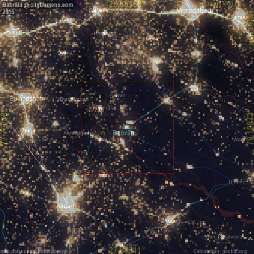
Analysis of Babrāla night lights 2016
Square area 10x10 km:
 1.98%
1.98%90-99
2.38%80-89
4.37%70-79
3.37%60-69
3.77%50-59
3.57%40-49
3.17%30-39
2.38%20-29
2.98%10-19
41.67%0-9
30.36%Square area 50x50 km:
0.38%90-99
0.54%80-89
0.7%70-79
0.58%60-69
1.57%50-59
1.9%40-49
2.89%30-39
3%20-29
4.37%10-19
9.87%0-9
74.2%Clear (daylight) street map image can be seen on geolist.org.
Map coordinates:
28° 52' 54" North, 77° 42' 8.9" East
28° 15' 51.1" North, 78° 24' 20.2" East
27° 38' 35.2" North, 79° 6' 31.4" East
Some cities around Babrāla sort by population:
• Atraulī
28.6 km =17.8 mi,  204°
204°
• Dibai
15.4 km =9.6 mi,  246°
246°
• Bahjoi
26.1 km =16.2 mi,  56°
56°
• Islāmnagar
32.1 km =19.9 mi,  77°
77°
• Anūpshahr
16.9 km =10.5 mi,  307°
307°
• Naraura
7.2 km =4.5 mi,  194°
194°
• Gunnaur
4.3 km =2.7 mi,  128°
128°
• Gawān
18.1 km =11.2 mi,  343°
343°
1278052 (p: 16,670)
Sources (retrieved 2019-11-25):
» Earth at Night: Flat Maps 2012, 2016