Muntilan night lights from space
Night Light of Muntilan (Central Java) from space (Indonesia) Src. Average luminocity for 10x10km area is 11.368% and for 50x50km: 13.0548%.
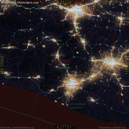

Analysis of Muntilan night lights 2016
Square area 10x10 km:
 0%
0%90-99
0%80-89
1.73%70-79
1.08%60-69
4.11%50-59
2.6%40-49
1.52%30-39
2.6%20-29
2.38%10-19
2.81%0-9
81.17%Square area 50x50 km:
1.47%90-99
1.23%80-89
1.48%70-79
1.92%60-69
2.81%50-59
2.83%40-49
2.24%30-39
2.37%20-29
3.31%10-19
5.38%0-9
74.96%Clear (daylight) street map image can be seen on geolist.org.
Map coordinates:
6° 53' 0.9" South, 109° 35' 22.8" East
7° 34' 52" South, 110° 17' 34" East
8° 16' 39" South, 110° 59' 45.3" East
Some cities around Muntilan sort by population:
• Yogyakarta
25.7 km =16 mi,  162°
162°
• Magelang
14.8 km =9.2 mi,  326°
326°
• Depok
25.3 km =15.7 mi,  142°
142°
• Mertoyudan
10 km =6.2 mi,  312°
312°
• Melati
18.8 km =11.7 mi,  154°
154°
• Gamping Lor
24.1 km =15 mi,  171°
171°
• Godean
21 km =13 mi,  179°
179°
• Sleman
16.5 km =10.3 mi, 155°
1634680 (p: 44,859)
Sources (retrieved 2019-11-25):
» Earth at Night: Flat Maps 2012, 2016