Mlonggo night lights from space
Night Light of Mlonggo (Central Java) from space (Indonesia) Src. Average luminocity for 10x10km area is 28.6732% and for 50x50km: 9.6428%.

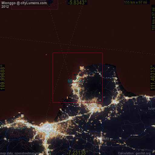
Analysis of Mlonggo night lights 2016
Square area 10x10 km:
 0%
0%90-99
3.46%80-89
2.81%70-79
1.95%60-69
4.55%50-59
5.63%40-49
8.01%30-39
8.44%20-29
10.17%10-19
40.69%0-9
14.29%Square area 50x50 km:
0.11%90-99
1.2%80-89
1.27%70-79
0.92%60-69
1.66%50-59
1.93%40-49
2.01%30-39
2.47%20-29
3.5%10-19
8.62%0-9
76.31%Clear (daylight) street map image can be seen on geolist.org.
Map coordinates:
5° 50' 3.5" South, 109° 59' 48.8" East
6° 31' 60" South, 110° 42' 0" East
7° 13' 53" South, 111° 24' 11.3" East
Some cities around Mlonggo sort by population:
• Batang
5.5 km =3.4 mi,  9°
9°
• Kudus
33.9 km =21.1 mi,  152°
152°
• Pecangaan
18.3 km =11.4 mi,  176°
176°
• Baekrajan
31.1 km =19.3 mi, 146°
• Gebog
27.5 km =17.1 mi,  144°
144°
• Jekulo
39.3 km =24.4 mi, 140°
• Tayu
38.9 km =24.2 mi,  91°
91°
• Welahan
29.7 km =18.5 mi, 176°
1635164 (p: 33,542)
Sources (retrieved 2019-11-25):
» Earth at Night: Flat Maps 2012, 2016