Krian night lights from space
Night Light of Krian (East Java) from space (Indonesia) Src. Average luminocity for 10x10km area is 85.0433% and for 50x50km: 65.2558%.
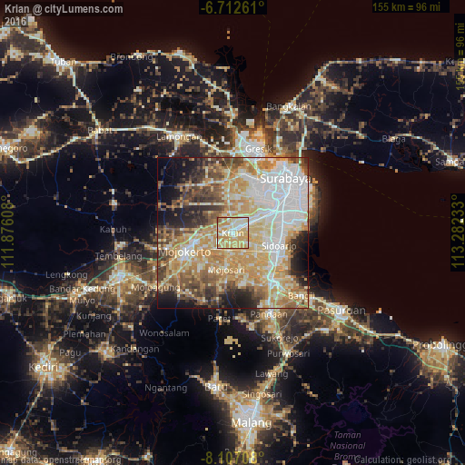

Analysis of Krian night lights 2016
Square area 10x10 km:
 11.26%
90-99
29.44%80-89
21.86%70-79
34.2%60-69
1.73%50-59
1.3%40-49
0.22%30-39
0%20-29
0%10-19
0%0-9
0%Square area 50x50 km:
13.78%90-99
14.9%80-89
10.94%70-79
14.95%60-69
8.63%50-59
5.65%40-49
7.98%30-39
5.5%20-29
6.31%10-19
7.12%0-9
4.24%Clear (daylight) street map image can be seen on geolist.org.
Map coordinates:
6° 42' 45.4" South, 111° 52' 33.9" East
7° 24' 37.4" South, 112° 34' 45.1" East
8° 6' 25.5" South, 113° 16' 56.4" East
Some cities around Krian sort by population:
• Sidoarjo
15.9 km =9.9 mi,  105°
105°
• Mojokerto
17.2 km =10.7 mi,  248°
248°
• Gedangan
16.4 km =10.2 mi,  82°
82°
• Tulangan Utara
10.6 km =6.6 mi,  131°
131°
• Buduran
16 km =9.9 mi,  97°
97°
• Tanggulangin
16.6 km =10.3 mi, 126°
• Driyorejo
6.8 km =4.2 mi,  43°
43°
• Soko
18.6 km =11.6 mi,  244°
244°
1639356 (p: 38,603)
Sources (retrieved 2019-11-25):
» Earth at Night: Flat Maps 2012, 2016