Balapulang night lights from space
Night Light of Balapulang (Central Java) from space (Indonesia) Src. Average luminocity for 10x10km area is 17.0346% and for 50x50km: 13.682%.

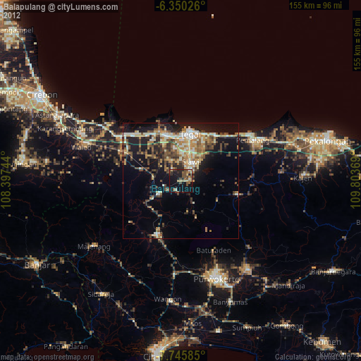
Analysis of Balapulang night lights 2016
Square area 10x10 km:
 0%
0%90-99
0%80-89
0.87%70-79
1.08%60-69
1.08%50-59
6.06%40-49
9.09%30-39
6.93%20-29
2.38%10-19
18.18%0-9
54.33%Square area 50x50 km:
0.67%90-99
1.34%80-89
1.57%70-79
1.31%60-69
2.48%50-59
3.37%40-49
3.7%30-39
3.5%20-29
4.12%10-19
8.57%0-9
69.38%Clear (daylight) street map image can be seen on geolist.org.
Map coordinates:
6° 21' 0.9" South, 108° 23' 50.8" East
7° 2' 54.9" South, 109° 6' 2" East
7° 44' 45.1" South, 109° 48' 13.3" East
Some cities around Balapulang sort by population:
• Tegal
20.4 km =12.7 mi,  12°
12°
• Adiwerna
12.8 km =8 mi,  15°
15°
• Dukuhturi
16.6 km =10.3 mi,  353°
353°
• Tarub
14.7 km =9.1 mi,  29°
29°
• Slawi
8.7 km =5.4 mi, 30°
• Lebaksiu
4.8 km =3 mi,  91°
91°
• Margasari
10.9 km =6.8 mi,  238°
238°
• Bulakamba
25.1 km =15.6 mi,  320°
320°
1650572 (p: 28,483)
Sources (retrieved 2019-11-25):
» Earth at Night: Flat Maps 2012, 2016