Sülysáp night lights from space
Night Light of Sülysáp (Pest) from space (Hungary) Src. Average luminocity for 10x10km area is 1.706% and for 50x50km: 9.08%.
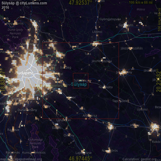
Analysis of Sülysáp night lights 2016
Square area 10x10 km:
100  0%
0%
90-99 0%
80-89 0%
70-79 0%
60-69 0.28%
50-59 0.57%
40-49 0.57%
30-39 1.14%
20-29 0.57%
10-19 1.14%
0-9 95.74%
0%90-99
0%80-89
0%70-79
0%60-69
0.28%50-59
0.57%40-49
0.57%30-39
1.14%20-29
0.57%10-19
1.14%0-9
95.74%Square area 50x50 km:
100 1.09%
90-99 1.46%
80-89 0.8%
70-79 0.92%
60-69 1.16%
50-59 1.66%
40-49 1.76%
30-39 1.84%
20-29 2.23%
10-19 6.64%
0-9 80.45%
1.09%90-99
1.46%80-89
0.8%70-79
0.92%60-69
1.16%50-59
1.66%40-49
1.76%30-39
1.84%20-29
2.23%10-19
6.64%0-9
80.45%Clear (daylight) street map image can be seen on geolist.org.
Map coordinates:
47° 55' 31.3" North, 18° 49' 50.1" East
47° 27' 7.4" North, 19° 32' 1.3" East
46° 58' 28" North, 20° 14' 12.6" East
Some cities around Sülysáp sort by population:
• Monor
12.9 km =8 mi,  210°
210°
• Gyömrő
10.3 km =6.4 mi,  254°
254°
• Nagykáta
16.3 km =10.1 mi,  104°
104°
• Pécel
15 km =9.3 mi,  286°
286°
• Isaszeg
13.2 km =8.2 mi,  311°
311°
• Üllő
15.2 km =9.4 mi,  241°
241°
• Maglód
12.8 km =8 mi,  265°
265°
• Tápiószecső
5.7 km =3.5 mi,  92°
92°
3044154 (p: 8,258)
Sources (retrieved 2019-11-25):
» Earth at Night: Flat Maps 2012, 2016