Sárospatak night lights from space
Night Light of Sárospatak (Borsod-Abaúj-Zemplén) from space (Hungary) Src. Average luminocity for 10x10km area is 3.5994% and for 50x50km: 0.5548%.
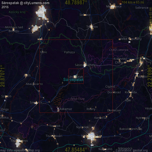
Analysis of Sárospatak night lights 2016
Square area 10x10 km:
 0.57%
0.57%90-99
0.57%80-89
0.57%70-79
0.28%60-69
0.85%50-59
0.14%40-49
0.43%30-39
0%20-29
0.71%10-19
0.99%0-9
94.89%Square area 50x50 km:
0.06%90-99
0.14%80-89
0.02%70-79
0.05%60-69
0.07%50-59
0.1%40-49
0.08%30-39
0.13%20-29
0.05%10-19
0.1%0-9
99.2%Clear (daylight) street map image can be seen on geolist.org.
Map coordinates:
48° 47' 23.5" North, 20° 52' 14.6" East
48° 19' 28.2" North, 21° 34' 25.8" East
47° 51' 17.4" North, 22° 16' 37.1" East
Some cities around Sárospatak sort by population:
• Sátoraljaújhely
10 km =6.2 mi,  38°
38°
• Szerencs
32.6 km =20.3 mi,  235°
235°
• Encs
32.6 km =20.3 mi,  271°
271°
• Ibrány
24.5 km =15.2 mi,  155°
155°
• Nagyhalász
25.4 km =15.8 mi,  146°
146°
• Rakamaz
23.8 km =14.8 mi,  199°
199°
• Tokaj
25.9 km =16.1 mi,  206°
206°
• Kemecse
32.6 km =20.3 mi, 148°
715867 (p: 14,478)
Sources (retrieved 2019-11-25):
» Earth at Night: Flat Maps 2012, 2016