Szerencs night lights from space
Night Light of Szerencs (Borsod-Abaúj-Zemplén) from space (Hungary) Src. Average luminocity for 10x10km area is 3.3646% and for 50x50km: 0.9769%.
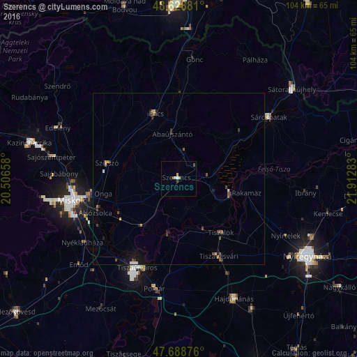
Analysis of Szerencs night lights 2016
Square area 10x10 km:
 0.6%
0.6%90-99
0.6%80-89
0%70-79
1.19%60-69
0%50-59
0.74%40-49
0.45%30-39
0.6%20-29
0%10-19
0%0-9
95.83%Square area 50x50 km:
0.06%90-99
0.07%80-89
0.07%70-79
0.1%60-69
0.09%50-59
0.25%40-49
0.26%30-39
0.22%20-29
0.14%10-19
0.59%0-9
98.13%Clear (daylight) street map image can be seen on geolist.org.
Map coordinates:
48° 37' 36.5" North, 20° 30' 23.7" East
48° 9' 35.7" North, 21° 12' 34.9" East
47° 41' 19.5" North, 21° 54' 46.2" East
Some cities around Szerencs sort by population:
• Tiszavasvári
23.9 km =14.9 mi,  154°
154°
• Felsőzsolca
26.3 km =16.3 mi,  255°
255°
• Encs
20.1 km =12.5 mi,  343°
343°
• Tiszalök
20.5 km =12.7 mi,  141°
141°
• Szikszó
21 km =13 mi,  282°
282°
• Tiszalúc
17 km =10.6 mi,  216°
216°
• Rakamaz
19.3 km =12 mi,  102°
102°
• Tokaj
16.1 km =10 mi,  107°
107°
715302 (p: 10,046)
Sources (retrieved 2019-11-25):
» Earth at Night: Flat Maps 2012, 2016