Encs night lights from space
Night Light of Encs (Borsod-Abaúj-Zemplén) from space (Hungary) Src. Average luminocity for 10x10km area is 2.3707% and for 50x50km: 0.9363%.
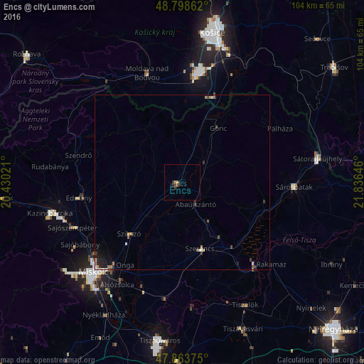
Analysis of Encs night lights 2016
Square area 10x10 km:
 0%
0%90-99
0%80-89
0.57%70-79
0.57%60-69
0%50-59
0.71%40-49
0.43%30-39
0.28%20-29
0.85%10-19
2.27%0-9
94.32%Square area 50x50 km:
0.09%90-99
0.11%80-89
0.05%70-79
0.19%60-69
0.12%50-59
0.14%40-49
0.12%30-39
0.22%20-29
0.19%10-19
0.61%0-9
98.16%Clear (daylight) street map image can be seen on geolist.org.
Map coordinates:
48° 47' 55" North, 20° 25' 48.8" East
48° 19' 60" North, 21° 7' 60" East
47° 51' 49.5" North, 21° 50' 11.3" East
Some cities around Encs sort by population:
• Sárospatak
32.6 km =20.3 mi,  91°
91°
• Edelény
29.8 km =18.5 mi,  262°
262°
• Szerencs
20.1 km =12.5 mi,  163°
163°
• Moldava nad Bodvou, SK
32.8 km =20.4 mi,  342°
342°
• Felsőzsolca
32.6 km =20.3 mi,  217°
217°
• Szikszó
21 km =13 mi, 224°
• Tiszalúc
33.2 km =20.6 mi,  187°
187°
• Tokaj
32 km =19.9 mi,  138°
138°
721159 (p: 6,886)
Sources (retrieved 2019-11-25):
» Earth at Night: Flat Maps 2012, 2016