Gyomaendrőd night lights from space
Night Light of Gyomaendrőd (Bekes) from space (Hungary) Src. Average luminocity for 10x10km area is 3.8494% and for 50x50km: 1.1064%.
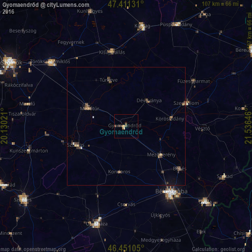
Analysis of Gyomaendrőd night lights 2016
Square area 10x10 km:
 0%
0%90-99
0.43%80-89
0.28%70-79
0.99%60-69
0.57%50-59
1.14%40-49
0.57%30-39
1.7%20-29
0%10-19
0.57%0-9
93.75%Square area 50x50 km:
0.04%90-99
0.05%80-89
0.08%70-79
0.12%60-69
0.18%50-59
0.25%40-49
0.4%30-39
0.38%20-29
0.19%10-19
0.41%0-9
97.9%Clear (daylight) street map image can be seen on geolist.org.
Map coordinates:
47° 24' 40.7" North, 20° 7' 48.8" East
46° 55' 60" North, 20° 49' 60" East
46° 27' 3.8" North, 21° 32' 11.3" East
Some cities around Gyomaendrőd sort by population:
• Mezőtúr
16.9 km =10.5 mi,  296°
296°
• Szarvas
22.8 km =14.2 mi,  250°
250°
• Mezőberény
20 km =12.4 mi,  130°
130°
• Túrkeve
19.6 km =12.2 mi,  341°
341°
• Szeghalom
27.6 km =17.1 mi,  66°
66°
• Dévaványa
15 km =9.3 mi,  42°
42°
• Kondoros
18.7 km =11.6 mi,  187°
187°
• Körösladány
19.3 km =12 mi,  78°
78°
720364 (p: 15,194)
Sources (retrieved 2019-11-25):
» Earth at Night: Flat Maps 2012, 2016