Bicske night lights from space
Night Light of Bicske (Fejér) from space (Hungary) Src. Average luminocity for 10x10km area is 5.1165% and for 50x50km: 9.6235%.
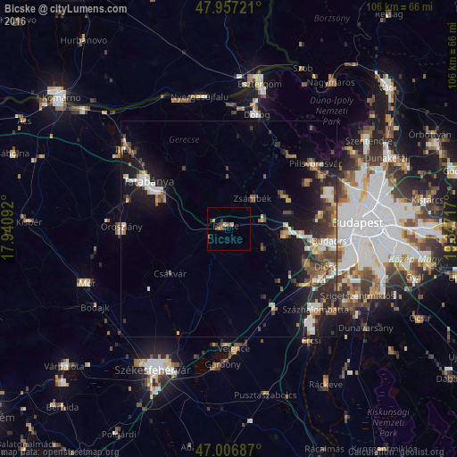
Analysis of Bicske night lights 2016
Square area 10x10 km:
 0%
0%90-99
0.28%80-89
0.71%70-79
1.14%60-69
0.57%50-59
0.57%40-49
2.41%30-39
2.13%20-29
0.14%10-19
0.57%0-9
91.48%Square area 50x50 km:
1.01%90-99
1.64%80-89
0.85%70-79
0.94%60-69
1.19%50-59
1.53%40-49
1.77%30-39
1.78%20-29
2.86%10-19
7.81%0-9
78.61%Clear (daylight) street map image can be seen on geolist.org.
Map coordinates:
47° 57' 26" North, 17° 56' 27.3" East
47° 29' 3.1" North, 18° 38' 38.5" East
47° 0' 24.7" North, 19° 20' 49.8" East
Some cities around Bicske sort by population:
• Budakeszi
21.5 km =13.4 mi,  82°
82°
• Törökbálint
21.2 km =13.2 mi,  106°
106°
• Biatorbágy
13.2 km =8.2 mi,  96°
96°
• Tárnok
19.6 km =12.2 mi,  129°
129°
• Piliscsaba
21.7 km =13.5 mi,  39°
39°
• Páty
14.3 km =8.9 mi, 75°
• Csákvár
16.9 km =10.5 mi,  232°
232°
• Martonvásár
21.7 km =13.5 mi,  149°
149°
3055030 (p: 11,072)
Sources (retrieved 2019-11-25):
» Earth at Night: Flat Maps 2012, 2016