Berettyóújfalu night lights from space
Night Light of Berettyóújfalu (Hajdú-Bihar) from space (Hungary) Src. Average luminocity for 10x10km area is 8.1518% and for 50x50km: 2.0004%.
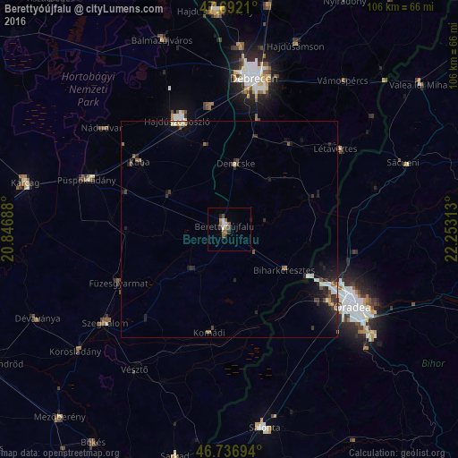
Analysis of Berettyóújfalu night lights 2016
Square area 10x10 km:
 1.49%
1.49%90-99
0.89%80-89
0%70-79
0.6%60-69
1.79%50-59
2.38%40-49
1.19%30-39
1.19%20-29
1.19%10-19
0.3%0-9
88.99%Square area 50x50 km:
0.2%90-99
0.31%80-89
0.09%70-79
0.13%60-69
0.24%50-59
0.3%40-49
0.32%30-39
0.47%20-29
0.82%10-19
1.53%0-9
95.6%Clear (daylight) street map image can be seen on geolist.org.
Map coordinates:
47° 41' 31.6" North, 20° 50' 48.8" East
47° 13' 0" North, 21° 33' 0" East
46° 44' 13" North, 22° 15' 11.3" East
Some cities around Berettyóújfalu sort by population:
• Oradea, RO
33.7 km =20.9 mi,  124°
124°
• Hajdúszoboszló
28.3 km =17.6 mi,  336°
336°
• Derecske
14.9 km =9.3 mi,  4°
4°
• Létavértes
32.2 km =20 mi,  54°
54°
• Füzesgyarmat
28.3 km =17.6 mi,  242°
242°
• Kaba
25 km =15.5 mi,  306°
306°
• Komádi
24.4 km =15.2 mi,  188°
188°
• Hosszúpályi
24 km =14.9 mi,  35°
35°
722324 (p: 16,090)
Sources (retrieved 2019-11-25):
» Earth at Night: Flat Maps 2012, 2016