Polýkastro night lights from space
Night Light of Polýkastro (Central Macedonia) from space (Greece) Src. Average luminocity for 10x10km area is 9.8027% and for 50x50km: 4.4465%.
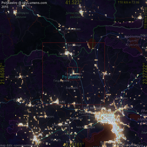
Analysis of Polýkastro night lights 2016
Square area 10x10 km:
 0%
0%90-99
1.36%80-89
1.87%70-79
0.17%60-69
1.87%50-59
2.21%40-49
1.7%30-39
1.7%20-29
3.91%10-19
1.53%0-9
83.67%Square area 50x50 km:
0.29%90-99
0.7%80-89
0.47%70-79
0.53%60-69
0.62%50-59
0.54%40-49
0.64%30-39
0.69%20-29
1.06%10-19
2.25%0-9
92.22%Clear (daylight) street map image can be seen on geolist.org.
Map coordinates:
41° 31' 22.8" North, 21° 51' 57.5" East
40° 59' 40" North, 22° 34' 8.7" East
40° 27' 41.8" North, 23° 16' 20" East
Some cities around Polýkastro sort by population:
• Giannitsá
26.3 km =16.3 mi,  211°
211°
• Kilkís
25.6 km =15.9 mi,  90°
90°
• Gevgelija, MK
17.3 km =10.7 mi,  340°
340°
• Bogdanci, MK
23.2 km =14.4 mi,  1°
1°
• Koufália
24.1 km =15 mi,  179°
179°
• Krýa Vrýsi
40.7 km =25.3 mi, 213°
• Valandovo, MK
35.9 km =22.3 mi,  358°
358°
• Star Dojran, MK
24.8 km =15.4 mi,  30°
30°
734540 (p: 7,064)
Sources (retrieved 2019-11-25):
» Earth at Night: Flat Maps 2012, 2016