Lagkadás night lights from space
Night Light of Lagkadás (Central Macedonia) from space (Greece) Src. Average luminocity for 10x10km area is 26.3555% and for 50x50km: 17.2541%.
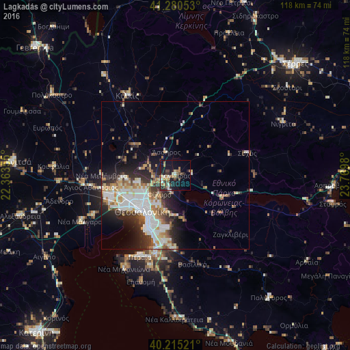
Analysis of Lagkadás night lights 2016
Square area 10x10 km:
 1.14%
1.14%90-99
4.71%80-89
2.27%70-79
4.06%60-69
4.87%50-59
3.08%40-49
5.68%30-39
3.73%20-29
7.47%10-19
26.14%0-9
36.85%Square area 50x50 km:
3.76%90-99
4.02%80-89
1.56%70-79
1.79%60-69
2.24%50-59
1.81%40-49
1.79%30-39
2.75%20-29
4.53%10-19
6.25%0-9
69.52%Clear (daylight) street map image can be seen on geolist.org.
Map coordinates:
41° 16' 49.9" North, 22° 21' 48.8" East
40° 45' 0" North, 23° 4' 0" East
40° 12' 54.8" North, 23° 46' 11.3" East
Some cities around Lagkadás sort by population:
• Thessaloníki
16.5 km =10.3 mi,  224°
224°
• Sykiés
14.8 km =9.2 mi, 221°
• Políchni
13.6 km =8.5 mi,  227°
227°
• Neapoli
15.1 km =9.4 mi, 224°
• Oraiókastro
12.8 km =8 mi,  260°
260°
• Triandría
16.8 km =10.4 mi,  206°
206°
• Ágios Pávlos
15.1 km =9.4 mi, 216°
• Asvestochóri
12.6 km =7.8 mi,  196°
196°
735481 (p: 7,215)
Sources (retrieved 2019-11-25):
» Earth at Night: Flat Maps 2012, 2016