Forécariah night lights from space
Night Light of Forécariah (Kindia) from space (Guinea) Src. Average luminocity for 10x10km area is 0.2121% and for 50x50km: 0.0161%.
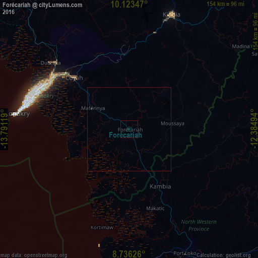
Analysis of Forécariah night lights 2016
Square area 10x10 km:
 0%
0%90-99
0%80-89
0%70-79
0%60-69
0%50-59
0%40-49
0%30-39
0%20-29
0%10-19
0.87%0-9
99.13%Square area 50x50 km:
0%90-99
0%80-89
0%70-79
0%60-69
0%50-59
0%40-49
0%30-39
0%20-29
0.03%10-19
0.03%0-9
99.93%Clear (daylight) street map image can be seen on geolist.org.
Map coordinates:
10° 7' 24.5" North, 13° 47' 28.3" West
9° 25' 50" North, 13° 5' 17" West
8° 44' 10.5" North, 12° 23' 5.8" West
Some cities around Forécariah sort by population:
• Camayenne
66.8 km =41.5 mi,  280°
280°
• Conakry
65.7 km =40.8 mi, 280°
• Coyah
44.7 km =27.8 mi,  313°
313°
• Kambia, SL
38.8 km =24.1 mi,  151°
151°
• Dubréka
62.3 km =38.7 mi, 310°
• Kukuna, SL
46.6 km =29 mi,  94°
94°
• Mambolo, SL
57.2 km =35.5 mi,  174°
174°
• Kassiri, SL
54.8 km =34.1 mi,  183°
183°
2420985 (p: 12,358)
Sources (retrieved 2019-11-25):
» Earth at Night: Flat Maps 2012, 2016