Surami night lights from space
Night Light of Surami (Shida Kartli) from space (Georgia) Src. Average luminocity for 10x10km area is 6.3016% and for 50x50km: 0.5236%.
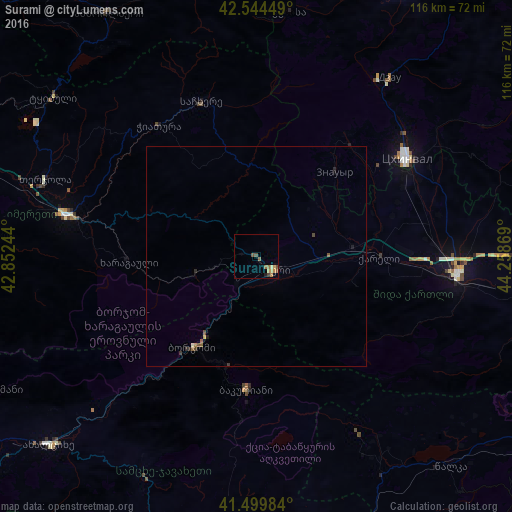
Analysis of Surami night lights 2016
Square area 10x10 km:
 0%
0%90-99
0%80-89
0.63%70-79
2.86%60-69
1.11%50-59
2.06%40-49
2.06%30-39
0.16%20-29
0.16%10-19
0.63%0-9
90.32%Square area 50x50 km:
0%90-99
0.02%80-89
0.03%70-79
0.15%60-69
0.06%50-59
0.19%40-49
0.17%30-39
0.06%20-29
0.14%10-19
0.08%0-9
99.1%Clear (daylight) street map image can be seen on geolist.org.
Map coordinates:
42° 32' 40.2" North, 42° 51' 8.8" East
42° 1' 27.5" North, 43° 33' 20" East
41° 29' 59.4" North, 44° 15' 31.3" East
Some cities around Surami sort by population:
• Gori
46.5 km =28.9 mi,  95°
95°
• Ts’khinvali
40.9 km =25.4 mi,  56°
56°
• Khashuri
5 km =3.1 mi,  132°
132°
• Zestap’oni
42.6 km =26.5 mi,  282°
282°
• Borjomi
22.4 km =13.9 mi,  211°
211°
• Chiat’ura
37.1 km =23.1 mi,  325°
325°
• Sach’khere
37.4 km =23.2 mi,  342°
342°
• Agara
22.2 km =13.8 mi,  86°
86°
611809 (p: 10,091)
Sources (retrieved 2019-11-25):
» Earth at Night: Flat Maps 2012, 2016