Skipton night lights from space
Night Light of Skipton (England) from space (United Kingdom) Src. Average luminocity for 10x10km area is 4.1746% and for 50x50km: 12.7272%.
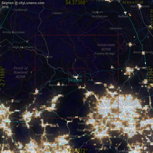
Analysis of Skipton night lights 2016
Square area 10x10 km:
 0.66%
0.66%90-99
0.4%80-89
0.26%70-79
0.79%60-69
0.53%50-59
0.13%40-49
0.4%30-39
0.79%20-29
1.19%10-19
0.26%0-9
94.58%Square area 50x50 km:
2.75%90-99
2.66%80-89
1.05%70-79
1.48%60-69
1.78%50-59
1.83%40-49
1.45%30-39
1.44%20-29
2.31%10-19
7.06%0-9
76.2%Clear (daylight) street map image can be seen on geolist.org.
Map coordinates:
54° 22' 23" North, 2° 43' 11.6" West
53° 57' 41.2" North, 2° 1' 0.3" West
53° 32' 44.6" North, 1° 18' 49.1" West
Some cities around Skipton sort by population:
• Keighley
12.7 km =7.9 mi,  145°
145°
• Colne
15.3 km =9.5 mi,  220°
220°
• Ilkley
13.3 km =8.3 mi,  107°
107°
• Cross Hills
6.5 km =4 mi,  161°
161°
• Barnoldswick
12.2 km =7.6 mi,  246°
246°
• Silsden
7.3 km =4.5 mi,  135°
135°
• Glusburn
6.9 km =4.3 mi,  170°
170°
• Haworth
15.4 km =9.6 mi, 163°
2637702 (p: 14,623)
Sources (retrieved 2019-11-25):
» Earth at Night: Flat Maps 2012, 2016