Haworth night lights from space
Night Light of Haworth (England) from space (United Kingdom) Src. Average luminocity for 10x10km area is 17.0582% and for 50x50km: 25.7105%.
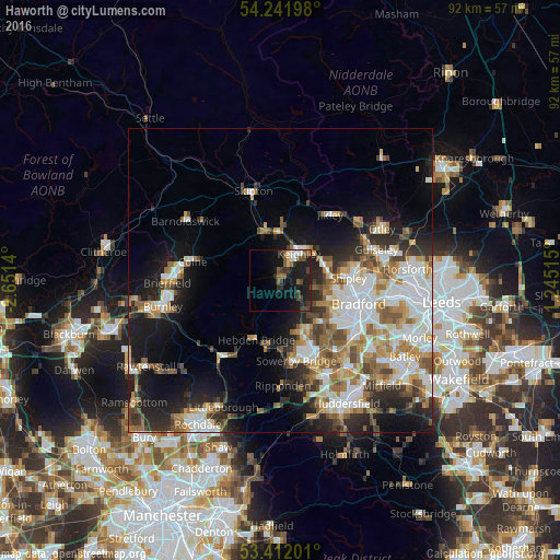
Analysis of Haworth night lights 2016
Square area 10x10 km:
 1.72%
1.72%90-99
1.72%80-89
1.19%70-79
0.13%60-69
1.19%50-59
5.29%40-49
3.44%30-39
3.84%20-29
5.16%10-19
25.53%0-9
50.79%Square area 50x50 km:
5.61%90-99
5.6%80-89
2.19%70-79
3.02%60-69
3.8%50-59
3.55%40-49
2.94%30-39
3.13%20-29
5.57%10-19
11.15%0-9
53.43%Clear (daylight) street map image can be seen on geolist.org.
Map coordinates:
54° 14' 31.1" North, 2° 39' 5" West
53° 49' 44.6" North, 1° 56' 53.8" West
53° 24' 43.2" North, 1° 14' 42.5" West
Some cities around Haworth sort by population:
• Keighley
5.1 km =3.2 mi,  32°
32°
• Bingley
7.5 km =4.7 mi,  73°
73°
• Baildon
10.7 km =6.6 mi,  79°
79°
• Cross Hills
8.9 km =5.5 mi,  344°
344°
• Queensbury
9.5 km =5.9 mi,  136°
136°
• Silsden
9.5 km =5.9 mi,  4°
4°
• Glusburn
8.6 km =5.3 mi, 336°
• Wilsden
5.9 km =3.7 mi,  98°
98°
2647278 (p: 6,213)
Sources (retrieved 2019-11-25):
» Earth at Night: Flat Maps 2012, 2016