Colinton night lights from space
Night Light of Colinton (Scotland) from space (United Kingdom) Src. Average luminocity for 10x10km area is 65.7356% and for 50x50km: 17.3303%.
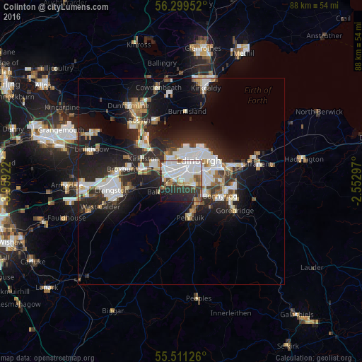
Analysis of Colinton night lights 2016
Square area 10x10 km:
 22.81%
90-99
21.05%80-89
4.76%70-79
4.51%60-69
4.26%50-59
3.76%40-49
4.39%30-39
9.4%20-29
14.66%10-19
9.4%0-9
1%Square area 50x50 km:
3.75%90-99
4.03%80-89
1.54%70-79
1.36%60-69
1.57%50-59
1.43%40-49
1.46%30-39
2.14%20-29
7.02%10-19
11.5%0-9
64.22%Clear (daylight) street map image can be seen on geolist.org.
Map coordinates:
56° 17' 58.3" North, 3° 57' 33.2" West
55° 54' 26.6" North, 3° 15' 21.9" West
55° 30' 40.5" North, 2° 33' 10.7" West
Some cities around Colinton sort by population:
• Edinburgh
6.2 km =3.9 mi,  36°
36°
• Bonnyrigg
10.1 km =6.3 mi,  111°
111°
• Penicuik
8.7 km =5.4 mi,  167°
167°
• Dalkeith
11.8 km =7.3 mi,  97°
97°
• Queensferry
12.8 km =8 mi,  316°
316°
• Currie
3.5 km =2.2 mi,  249°
249°
• Loanhead
6.8 km =4.2 mi,  117°
117°
• Balerno
5.8 km =3.6 mi,  243°
243°
2652577 (p: 7,637)
Sources (retrieved 2019-11-25):
» Earth at Night: Flat Maps 2012, 2016