Cleator Moor night lights from space
Night Light of Cleator Moor (England) from space (United Kingdom) Src. Average luminocity for 10x10km area is 8.4833% and for 50x50km: 1.5032%.
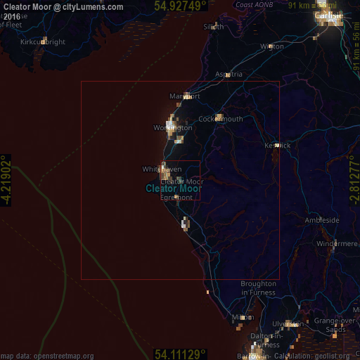
Analysis of Cleator Moor night lights 2016
Square area 10x10 km:
 0%
0%90-99
0.48%80-89
0%70-79
1.67%60-69
1.91%50-59
2.15%40-49
3.23%30-39
2.99%20-29
1.44%10-19
0.48%0-9
85.65%Square area 50x50 km:
0.11%90-99
0.16%80-89
0.16%70-79
0.21%60-69
0.17%50-59
0.26%40-49
0.32%30-39
0.27%20-29
0.24%10-19
0.59%0-9
97.5%Clear (daylight) street map image can be seen on geolist.org.
Map coordinates:
54° 55' 39" North, 4° 13' 8.5" West
54° 31' 17.1" North, 3° 30' 57.2" West
54° 6' 40.6" North, 2° 48' 46" West
Some cities around Cleator Moor sort by population:
• Workington
13.6 km =8.5 mi,  352°
352°
• Whitehaven
5.4 km =3.4 mi,  304°
304°
• Maryport
21.5 km =13.4 mi,  3°
3°
• Cockermouth
18.6 km =11.6 mi,  32°
32°
• Windermere
42.3 km =26.3 mi,  111°
111°
• Egremont
4.7 km =2.9 mi,  189°
189°
• Millom
38 km =23.6 mi,  155°
155°
• Wigton
40.7 km =25.3 mi, 34°
2652891 (p: 6,936)
Sources (retrieved 2019-11-25):
» Earth at Night: Flat Maps 2012, 2016