Villemoisson-sur-Orge night lights from space
Night Light of Villemoisson-sur-Orge (Île-de-France) from space (France) Src. Average luminocity for 10x10km area is 95.9673% and for 50x50km: 57.0033%.
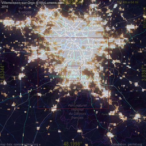
Analysis of Villemoisson-sur-Orge night lights 2016
Square area 10x10 km:
 50.74%
90-99
34.52%80-89
6.4%70-79
7.44%60-69
0.89%50-59
0%40-49
0%30-39
0%20-29
0%10-19
0%0-9
0%Square area 50x50 km:
24.02%90-99
14.21%80-89
4.1%70-79
4.26%60-69
5.03%50-59
3.73%40-49
5.37%30-39
5.31%20-29
5.85%10-19
7.24%0-9
20.87%Clear (daylight) street map image can be seen on geolist.org.
Map coordinates:
49° 7' 42.8" North, 1° 38' 0.4" East
48° 39' 58.8" North, 2° 20' 11.7" East
48° 11' 59.3" North, 3° 2' 22.9" East
Some cities around Villemoisson-sur-Orge sort by population:
• Savigny-sur-Orge
1.4 km =0.9 mi,  36°
36°
• Sainte-Geneviève-des-Bois
2.5 km =1.6 mi,  209°
209°
• Saint-Michel-sur-Orge
4.1 km =2.5 mi, 210°
• Longjumeau
3.8 km =2.4 mi,  326°
326°
• Morsang-sur-Orge
1.3 km =0.8 mi,  112°
112°
• Juvisy-sur-Orge
3.9 km =2.4 mi,  61°
61°
• Épinay-sur-Orge
2.1 km =1.3 mi,  292°
292°
• Fleury-Mérogis
3.8 km =2.4 mi,  148°
148°
2968655 (p: 7,250)
Sources (retrieved 2019-11-25):
» Earth at Night: Flat Maps 2012, 2016