Sormiou night lights from space
Night Light of Sormiou (Provence-Alpes-Côte d'Azur) from space (France) Src. Average luminocity for 10x10km area is 28.3121% and for 50x50km: 20.64%.
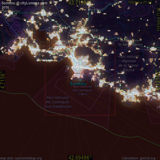
Analysis of Sormiou night lights 2016
Square area 10x10 km:
 5.76%
5.76%90-99
7.58%80-89
3.48%70-79
0.45%60-69
2.73%50-59
3.03%40-49
0.3%30-39
2.27%20-29
14.24%10-19
20.61%0-9
39.55%Square area 50x50 km:
5.11%90-99
4.57%80-89
1.81%70-79
1.48%60-69
1.99%50-59
2.1%40-49
2.17%30-39
3.57%20-29
7.36%10-19
10.5%0-9
59.34%Clear (daylight) street map image can be seen on geolist.org.
Map coordinates:
43° 43' 11.7" North, 4° 42' 56.2" East
43° 12' 34.5" North, 5° 25' 7.4" East
42° 41' 41.9" North, 6° 7' 18.7" East
Some cities around Sormiou sort by population:
• Marseille 09
5.1 km =3.2 mi,  348°
348°
• Mazargues
4.4 km =2.7 mi,  337°
337°
• Le Cabot
5.5 km =3.4 mi,  358°
358°
• La Pointe Rouge
4.7 km =2.9 mi,  313°
313°
• Vieille Chapelle
5.4 km =3.4 mi,  325°
325°
• Les Baumettes
1.9 km =1.2 mi, 354°
• La Panouse
5.2 km =3.2 mi,  9°
9°
• Bonneveine
5.3 km =3.3 mi, 327°
2974180 (p: 6,809)
Sources (retrieved 2019-11-25):
» Earth at Night: Flat Maps 2012, 2016