Le Cabot night lights from space
Night Light of Le Cabot (Provence-Alpes-Côte d'Azur) from space (France) Src. Average luminocity for 10x10km area is 73.1136% and for 50x50km: 25.4411%.
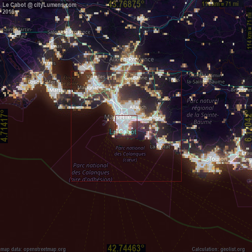
Analysis of Le Cabot night lights 2016
Square area 10x10 km:
 34.39%
90-99
21.06%80-89
4.7%70-79
0.76%60-69
5%50-59
4.7%40-49
2.27%30-39
8.33%20-29
12.42%10-19
6.06%0-9
0.3%Square area 50x50 km:
5.81%90-99
5.52%80-89
2.56%70-79
1.86%60-69
2.62%50-59
2.6%40-49
2.92%30-39
4.81%20-29
9.2%10-19
12.72%0-9
49.39%Clear (daylight) street map image can be seen on geolist.org.
Map coordinates:
43° 46' 7.5" North, 4° 42' 51" East
43° 15' 31.8" North, 5° 25' 2.2" East
42° 44' 40.7" North, 6° 7' 13.5" East
Some cities around Le Cabot sort by population:
• Marseille 09
1.1 km =0.7 mi,  241°
241°
• Marseille 10
2.2 km =1.4 mi,  355°
355°
• Sainte-Marguerite
1.3 km =0.8 mi,  284°
284°
• Mazargues
2.1 km =1.3 mi,  228°
228°
• Saint-Loup
2.4 km =1.5 mi,  28°
28°
• Saint-Tronc
1.4 km =0.9 mi,  18°
18°
• Sainte-Anne
1.9 km =1.2 mi,  264°
264°
• La Panouse
1.1 km =0.7 mi,  108°
108°
11919760 (p: 10,942)
Sources (retrieved 2019-11-25):
» Earth at Night: Flat Maps 2012, 2016