Vieille Chapelle night lights from space
Night Light of Vieille Chapelle (Provence-Alpes-Côte d'Azur) from space (France) Src. Average luminocity for 10x10km area is 58.2348% and for 50x50km: 24.0674%.
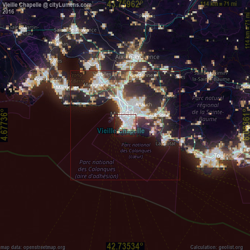
Analysis of Vieille Chapelle night lights 2016
Square area 10x10 km:
 23.48%
90-99
16.06%80-89
4.85%70-79
0.76%60-69
4.39%50-59
4.39%40-49
1.06%30-39
6.36%20-29
15.15%10-19
18.33%0-9
5.15%Square area 50x50 km:
5.59%90-99
5.21%80-89
2.31%70-79
1.78%60-69
2.42%50-59
2.5%40-49
2.57%30-39
4.55%20-29
9.05%10-19
12.46%0-9
51.58%Clear (daylight) street map image can be seen on geolist.org.
Map coordinates:
43° 45' 34.6" North, 4° 40' 38.5" East
43° 14' 58.7" North, 5° 22' 49.7" East
42° 44' 7.2" North, 6° 5' 1" East
Some cities around Vieille Chapelle sort by population:
• Marseille 08
2.4 km =1.5 mi,  3°
3°
• Marseille 09
2.1 km =1.3 mi,  75°
75°
• Sainte-Marguerite
2.2 km =1.4 mi,  50°
50°
• Mazargues
1.5 km =0.9 mi,  105°
105°
• Saint-Giniez
2.2 km =1.4 mi,  10°
10°
• Sainte-Anne
1.4 km =0.9 mi, 51°
• La Pointe Rouge
1.3 km =0.8 mi,  193°
193°
• Bonneveine
0.2 km =0.1 mi, 79°
2969332 (p: 8,181)
Sources (retrieved 2019-11-25):
» Earth at Night: Flat Maps 2012, 2016