Saint-Valery-en-Caux night lights from space
Night Light of Saint-Valery-en-Caux (Normandy) from space (France) Src. Average luminocity for 10x10km area is 5.1658% and for 50x50km: 1.6013%.
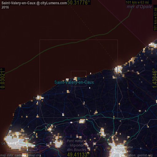
Analysis of Saint-Valery-en-Caux night lights 2016
Square area 10x10 km:
 1.07%
1.07%90-99
0.53%80-89
0.4%70-79
1.07%60-69
1.6%50-59
0.13%40-49
0%30-39
0%20-29
0.53%10-19
0.53%0-9
94.12%Square area 50x50 km:
0.26%90-99
0.26%80-89
0.13%70-79
0.16%60-69
0.21%50-59
0.22%40-49
0.16%30-39
0.17%20-29
0.14%10-19
0.82%0-9
97.48%Clear (daylight) street map image can be seen on geolist.org.
Map coordinates:
50° 19' 3.9" North, 0° 1' 48.8" East
49° 52' 0" North, 0° 43' 60" East
49° 24' 40.8" North, 1° 26' 11.3" East
Some cities around Saint-Valery-en-Caux sort by population:
• Dieppe
25.4 km =15.8 mi,  76°
76°
• Fécamp
28.4 km =17.6 mi,  244°
244°
• Barentin
39.1 km =24.3 mi,  155°
155°
• Bolbec
37.6 km =23.4 mi,  209°
209°
• Yvetot
27.8 km =17.3 mi,  176°
176°
• Lillebonne
41 km =25.5 mi,  200°
200°
• Notre-Dame-de-Gravenchon
43.5 km =27 mi, 195°
• Pavilly
36.9 km =22.9 mi,  154°
154°
2976703 (p: 5,017)
Sources (retrieved 2019-11-25):
» Earth at Night: Flat Maps 2012, 2016