Saint-Cyr-sur-Mer night lights from space
Night Light of Saint-Cyr-sur-Mer (Provence-Alpes-Côte d'Azur) from space (France) Src. Average luminocity for 10x10km area is 28.4515% and for 50x50km: 19.1226%.
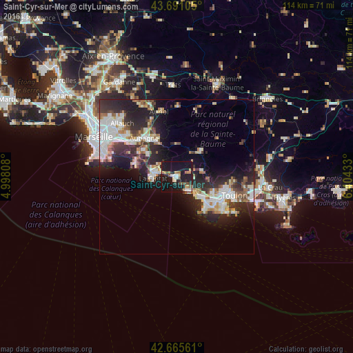
Analysis of Saint-Cyr-sur-Mer night lights 2016
Square area 10x10 km:
 3.64%
3.64%90-99
4.7%80-89
1.36%70-79
3.79%60-69
4.85%50-59
1.52%40-49
4.24%30-39
1.67%20-29
5.76%10-19
52.12%0-9
16.36%Square area 50x50 km:
4.09%90-99
4.22%80-89
1.68%70-79
1.32%60-69
2.27%50-59
1.82%40-49
1.91%30-39
2.95%20-29
7.52%10-19
11.12%0-9
61.1%Clear (daylight) street map image can be seen on geolist.org.
Map coordinates:
43° 41' 27.8" North, 4° 59' 53.1" East
43° 10' 49.7" North, 5° 42' 4.3" East
42° 39' 56.2" North, 6° 24' 15.6" East
Some cities around Saint-Cyr-sur-Mer sort by population:
• Six-Fours-les-Plages
14.1 km =8.8 mi,  134°
134°
• La Ciotat
7.9 km =4.9 mi,  265°
265°
• Sanary-sur-Mer
10.6 km =6.6 mi, 129°
• Ollioules
12.7 km =7.9 mi,  110°
110°
• Le Beausset
8.5 km =5.3 mi,  76°
76°
• Bandol
5.6 km =3.5 mi,  138°
138°
• Cassis
13.8 km =8.6 mi,  286°
286°
• Carnoux-en-Provence
13.9 km =8.6 mi,  307°
307°
2980933 (p: 12,185)
Sources (retrieved 2019-11-25):
» Earth at Night: Flat Maps 2012, 2016