Ollioules night lights from space
Night Light of Ollioules (Provence-Alpes-Côte d'Azur) from space (France) Src. Average luminocity for 10x10km area is 61.4455% and for 50x50km: 17.335%.
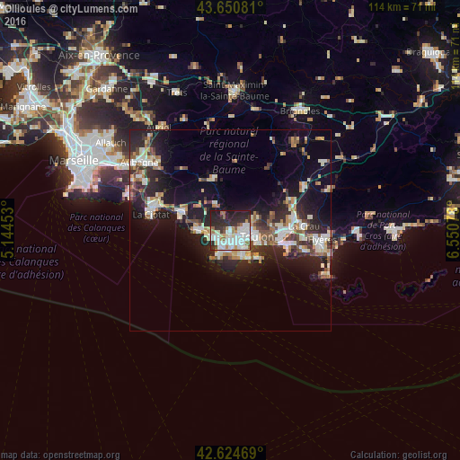
Analysis of Ollioules night lights 2016
Square area 10x10 km:
 18.48%
90-99
19.55%80-89
5.15%70-79
3.03%60-69
6.97%50-59
3.64%40-49
2.58%30-39
6.67%20-29
22.73%10-19
11.21%0-9
0%Square area 50x50 km:
2.74%90-99
3.63%80-89
1.76%70-79
1.55%60-69
2.06%50-59
1.81%40-49
2.15%30-39
2.37%20-29
6.76%10-19
11.84%0-9
63.33%Clear (daylight) street map image can be seen on geolist.org.
Map coordinates:
43° 39' 2.9" North, 5° 8' 40.3" East
43° 8' 23.6" North, 5° 50' 51.6" East
42° 37' 28.9" North, 6° 33' 2.8" East
Some cities around Ollioules sort by population:
• Toulon
6.8 km =4.2 mi,  104°
104°
• La Seyne-sur-Mer
4.8 km =3 mi,  148°
148°
• Six-Fours-les-Plages
5.7 km =3.5 mi,  199°
199°
• La Valette-du-Var
11 km =6.8 mi,  91°
91°
• Sanary-sur-Mer
4.4 km =2.7 mi,  239°
239°
• Le Beausset
7.4 km =4.6 mi,  330°
330°
• Bandol
8.2 km =5.1 mi,  272°
272°
• Saint-Mandrier-sur-Mer
9.5 km =5.9 mi,  136°
136°
2989590 (p: 13,916)
Sources (retrieved 2019-11-25):
» Earth at Night: Flat Maps 2012, 2016