Saint-Amand-Montrond night lights from space
Night Light of Saint-Amand-Montrond (Centre) from space (France) Src. Average luminocity for 10x10km area is 13.5268% and for 50x50km: 1.1196%.
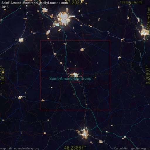
Analysis of Saint-Amand-Montrond night lights 2016
Square area 10x10 km:
 1.49%
1.49%90-99
2.23%80-89
1.79%70-79
2.83%60-69
1.64%50-59
1.19%40-49
0.74%30-39
1.34%20-29
0.74%10-19
3.27%0-9
82.74%Square area 50x50 km:
0.06%90-99
0.15%80-89
0.11%70-79
0.2%60-69
0.2%50-59
0.17%40-49
0.17%30-39
0.25%20-29
0.2%10-19
0.25%0-9
98.26%Clear (daylight) street map image can be seen on geolist.org.
Map coordinates:
47° 12' 9.7" North, 1° 48' 6.6" East
46° 43' 22.2" North, 2° 30' 17.8" East
46° 14' 19.2" North, 3° 12' 29.1" East
Some cities around Saint-Amand-Montrond sort by population:
• Bourges
40.9 km =25.4 mi,  348°
348°
• Montluçon
43.2 km =26.8 mi,  170°
170°
• Nevers
57.9 km =36 mi,  59°
59°
• Issoudun
46.3 km =28.8 mi,  302°
302°
• Varennes-Vauzelles
58.3 km =36.2 mi, 55°
• Domérat
40.4 km =25.1 mi,  176°
176°
• Commentry
51.6 km =32.1 mi,  159°
159°
• Mehun-sur-Yèvre
51.3 km =31.9 mi,  334°
334°
2981837 (p: 11,976)
Sources (retrieved 2019-11-25):
» Earth at Night: Flat Maps 2012, 2016