Rumilly night lights from space
Night Light of Rumilly (Auvergne-Rhône-Alpes) from space (France) Src. Average luminocity for 10x10km area is 9.744% and for 50x50km: 8.1201%.
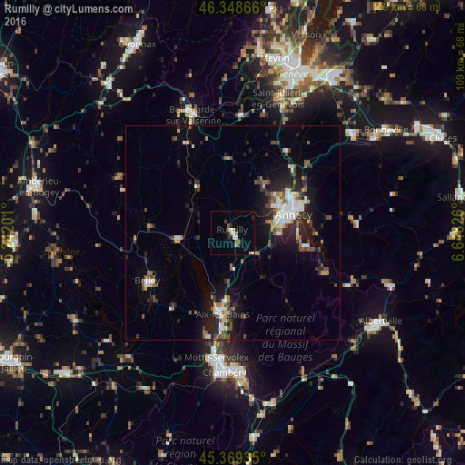
Analysis of Rumilly night lights 2016
Square area 10x10 km:
 1.34%
1.34%90-99
1.04%80-89
0.89%70-79
1.49%60-69
1.79%50-59
0.6%40-49
0.6%30-39
0.6%20-29
3.27%10-19
1.93%0-9
86.46%Square area 50x50 km:
0.98%90-99
1.34%80-89
0.68%70-79
0.71%60-69
0.86%50-59
1.23%40-49
1.25%30-39
1.28%20-29
2.87%10-19
5.32%0-9
83.5%Clear (daylight) street map image can be seen on geolist.org.
Map coordinates:
46° 20' 55.2" North, 5° 14' 31.2" East
45° 51' 40.2" North, 5° 56' 42.5" East
45° 22' 9.7" North, 6° 38' 53.7" East
Some cities around Rumilly sort by population:
• Annecy
14.9 km =9.3 mi,  69°
69°
• Aix-les-Bains
19.1 km =11.9 mi,  188°
188°
• Annecy-le-Vieux
16.7 km =10.4 mi, 67°
• Cran-Gevrier
12.7 km =7.9 mi, 70°
• Seynod
11.4 km =7.1 mi,  76°
76°
• Meythet
13.2 km =8.2 mi,  61°
61°
• Poisy
11.4 km =7.1 mi,  53°
53°
• Saint-Jorioz
16.8 km =10.4 mi,  101°
101°
2982159 (p: 13,077)
Sources (retrieved 2019-11-25):
» Earth at Night: Flat Maps 2012, 2016