Port-Saint-Louis-du-Rhône night lights from space
Night Light of Port-Saint-Louis-du-Rhône (Provence-Alpes-Côte d'Azur) from space (France) Src. Average luminocity for 10x10km area is 35.1667% and for 50x50km: 10.843%.
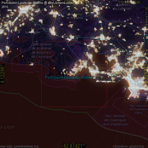
Analysis of Port-Saint-Louis-du-Rhône night lights 2016
Square area 10x10 km:
 3.81%
3.81%90-99
8.73%80-89
6.83%70-79
4.29%60-69
3.97%50-59
3.81%40-49
1.43%30-39
2.06%20-29
10.32%10-19
31.9%0-9
22.86%Square area 50x50 km:
1.69%90-99
2.13%80-89
1.24%70-79
1%60-69
0.75%50-59
1.25%40-49
0.96%30-39
1.24%20-29
5.44%10-19
9.5%0-9
74.79%Clear (daylight) street map image can be seen on geolist.org.
Map coordinates:
43° 53' 46.2" North, 4° 7' 22.7" East
43° 23' 14.4" North, 4° 49' 33.9" East
42° 52' 27.2" North, 5° 31' 45.2" East
Some cities around Port-Saint-Louis-du-Rhône sort by population:
• Martigues
18.6 km =11.6 mi,  83°
83°
• Istres
19.1 km =11.9 mi,  42°
42°
• Miramas
26.2 km =16.3 mi,  32°
32°
• Fos-sur-Mer
11.1 km =6.9 mi,  59°
59°
• Sausset-les-Pins
23.3 km =14.5 mi,  105°
105°
• Saint-Chamas
24.8 km =15.4 mi, 42°
• Carry-le-Rouet
27.1 km =16.8 mi,  103°
103°
• Saint-Mitre-les-Remparts
17 km =10.6 mi, 63°
2985934 (p: 8,503)
Sources (retrieved 2019-11-25):
» Earth at Night: Flat Maps 2012, 2016