Carry-le-Rouet night lights from space
Night Light of Carry-le-Rouet (Provence-Alpes-Côte d'Azur) from space (France) Src. Average luminocity for 10x10km area is 25.554% and for 50x50km: 26.8822%.
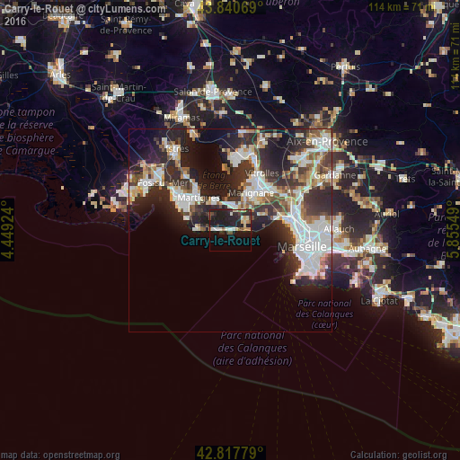
Analysis of Carry-le-Rouet night lights 2016
Square area 10x10 km:
 2.38%
2.38%90-99
5.24%80-89
2.38%70-79
3.81%60-69
0.95%50-59
1.9%40-49
3.33%30-39
2.54%20-29
14.76%10-19
28.25%0-9
34.44%Square area 50x50 km:
6.59%90-99
6.04%80-89
2.57%70-79
2.13%60-69
2.18%50-59
3.14%40-49
2.8%30-39
4.91%20-29
10.09%10-19
11.51%0-9
48.04%Clear (daylight) street map image can be seen on geolist.org.
Map coordinates:
43° 50' 26.5" North, 4° 26' 57.3" East
43° 19' 53" North, 5° 9' 8.5" East
42° 49' 4" North, 5° 51' 19.8" East
Some cities around Carry-le-Rouet sort by population:
• Martigues
11.5 km =7.1 mi,  317°
317°
• Marignane
10.8 km =6.7 mi,  27°
27°
• Châteauneuf-les-Martigues
5.9 km =3.7 mi,  9°
9°
• Gignac-la-Nerthe
9.6 km =6 mi,  44°
44°
• Sausset-les-Pins
3.9 km =2.4 mi,  269°
269°
• Saint-Victoret
11.8 km =7.3 mi, 33°
• L'Estaque
13.1 km =8.1 mi,  74°
74°
• Saint-Henri
14.8 km =9.2 mi,  76°
76°
3028510 (p: 6,434)
Sources (retrieved 2019-11-25):
» Earth at Night: Flat Maps 2012, 2016