Pauillac night lights from space
Night Light of Pauillac (Nouvelle-Aquitaine) from space (France) Src. Average luminocity for 10x10km area is 11.4621% and for 50x50km: 5.5598%.
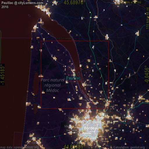
Analysis of Pauillac night lights 2016
Square area 10x10 km:
 0.45%
0.45%90-99
0.3%80-89
3.18%70-79
0.76%60-69
1.67%50-59
2.88%40-49
0.45%30-39
2.58%20-29
1.36%10-19
1.21%0-9
85.15%Square area 50x50 km:
0.31%90-99
0.59%80-89
0.52%70-79
0.77%60-69
0.96%50-59
0.69%40-49
0.73%30-39
0.91%20-29
1.38%10-19
4.3%0-9
88.84%Clear (daylight) street map image can be seen on geolist.org.
Map coordinates:
45° 41' 23.1" North, 1° 27' 6.7" West
45° 11' 47.2" North, 0° 44' 55.4" West
44° 41' 55.7" North, 0° 2' 44.2" West
Some cities around Pauillac sort by population:
• Saint-Médard-en-Jalles
33.4 km =20.8 mi,  176°
176°
• Blanquefort
32.8 km =20.4 mi,  164°
164°
• Le Taillan-Médoc
33 km =20.5 mi,  169°
169°
• Parempuyre
29.6 km =18.4 mi, 157°
• Le Pian-Médoc
27.7 km =17.2 mi, 165°
• Saint-Aubin-de-Médoc
31.7 km =19.7 mi, 176°
• Lesparre-Médoc
19.2 km =11.9 mi,  309°
309°
• Blaye
10.2 km =6.3 mi,  138°
138°
2988350 (p: 5,792)
Sources (retrieved 2019-11-25):
» Earth at Night: Flat Maps 2012, 2016