Fontaine-lès-Dijon night lights from space
Night Light of Fontaine-lès-Dijon (Bourgogne-Franche-Comté) from space (France) Src. Average luminocity for 10x10km area is 61.4449% and for 50x50km: 6.9099%.
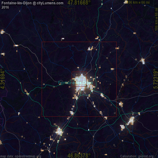
Analysis of Fontaine-lès-Dijon night lights 2016
Square area 10x10 km:
 26.93%
90-99
19.64%80-89
1.79%70-79
2.98%60-69
2.98%50-59
1.04%40-49
1.79%30-39
3.72%20-29
18.9%10-19
16.07%0-9
4.17%Square area 50x50 km:
1.77%90-99
1.5%80-89
0.49%70-79
0.46%60-69
0.63%50-59
0.5%40-49
0.42%30-39
0.93%20-29
2.37%10-19
3.79%0-9
87.14%Clear (daylight) street map image can be seen on geolist.org.
Map coordinates:
47° 49' 0" North, 4° 19' 1" East
47° 20' 32.6" North, 5° 1' 12.3" East
46° 51' 49.6" North, 5° 43' 23.5" East
Some cities around Fontaine-lès-Dijon sort by population:
• Dijon
2.9 km =1.8 mi,  185°
185°
• Chenôve
5.6 km =3.5 mi, 192°
• Talant
1 km =0.6 mi,  234°
234°
• Chevigny-Saint-Sauveur
9.8 km =6.1 mi,  119°
119°
• Quetigny
7.8 km =4.8 mi,  111°
111°
• Longvic
6.9 km =4.3 mi,  151°
151°
• Saint-Apollinaire
4.9 km =3 mi,  101°
101°
• Marsannay-la-Côte
8.3 km =5.2 mi,  196°
196°
3018032 (p: 9,234)
Sources (retrieved 2019-11-25):
» Earth at Night: Flat Maps 2012, 2016