Lillers night lights from space
Night Light of Lillers (Hauts-de-France) from space (France) Src. Average luminocity for 10x10km area is 26.6003% and for 50x50km: 19.4501%.
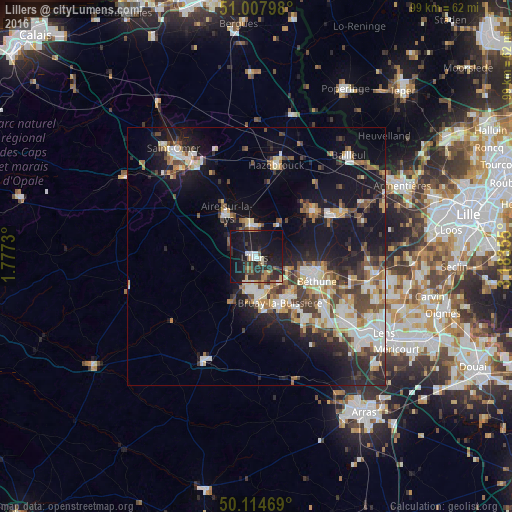
Analysis of Lillers night lights 2016
Square area 10x10 km:
 2.27%
2.27%90-99
2.27%80-89
2.81%70-79
1.74%60-69
3.07%50-59
2.81%40-49
4.14%30-39
6.42%20-29
15.37%10-19
43.72%0-9
15.37%Square area 50x50 km:
2.92%90-99
3.73%80-89
2.14%70-79
1.97%60-69
2.18%50-59
2.46%40-49
3.38%30-39
2.92%20-29
5.4%10-19
14.84%0-9
58.06%Clear (daylight) street map image can be seen on geolist.org.
Map coordinates:
51° 0' 28.7" North, 1° 46' 38.3" East
50° 33' 48.4" North, 2° 28' 49.5" East
50° 6' 52.9" North, 3° 11' 0.8" East
Some cities around Lillers sort by population:
• Bruay-la-Buissière
10.2 km =6.3 mi,  151°
151°
• Auchel
6.7 km =4.2 mi,  184°
184°
• Aire-sur-la-Lys
10.2 km =6.3 mi,  325°
325°
• Isbergues
6.8 km =4.2 mi,  347°
347°
• Divion
10.4 km =6.5 mi,  170°
170°
• Marles-les-Mines
6.8 km =4.2 mi,  162°
162°
• Calonne-Ricouart
8.7 km =5.4 mi, 183°
• Annezin
10.3 km =6.4 mi,  109°
109°
2998320 (p: 10,104)
Sources (retrieved 2019-11-25):
» Earth at Night: Flat Maps 2012, 2016