Les Ulis night lights from space
Night Light of Les Ulis (Île-de-France) from space (France) Src. Average luminocity for 10x10km area is 61.869% and for 50x50km: 49.9045%.

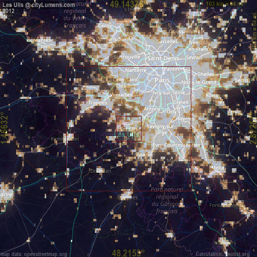
Analysis of Les Ulis night lights 2016
Square area 10x10 km:
 14.58%
90-99
15.77%80-89
6.1%70-79
7.74%60-69
8.18%50-59
6.4%40-49
11.01%30-39
7.59%20-29
13.1%10-19
9.23%0-9
0.3%Square area 50x50 km:
22.59%90-99
11.75%80-89
3.27%70-79
3.33%60-69
3.98%50-59
3.03%40-49
4.23%30-39
3.76%20-29
4.97%10-19
9.39%0-9
29.69%Clear (daylight) street map image can be seen on geolist.org.
Map coordinates:
49° 8' 37.5" North, 1° 27' 58.8" East
48° 40' 54" North, 2° 10' 10" East
48° 12' 55.1" North, 2° 52' 21.3" East
Some cities around Les Ulis sort by population:
• Palaiseau
7.2 km =4.5 mi,  55°
55°
• Gif-sur-Yvette
2.7 km =1.7 mi,  273°
273°
• Orsay
2 km =1.2 mi,  39°
39°
• Bures-sur-Yvette
2 km =1.2 mi,  2°
2°
• Villebon-sur-Yvette
5.9 km =3.7 mi, 62°
• Saint-Rémy-lès-Chevreuse
7.4 km =4.6 mi,  292°
292°
• Marcoussis
6.9 km =4.3 mi,  132°
132°
• Saulx-les-Chartreux
7.2 km =4.5 mi,  82°
82°
6615536 (p: 25,785)
Sources (retrieved 2019-11-25):
» Earth at Night: Flat Maps 2012, 2016