Le Luc night lights from space
Night Light of Le Luc (Provence-Alpes-Côte d'Azur) from space (France) Src. Average luminocity for 10x10km area is 10.6587% and for 50x50km: 10.4333%.
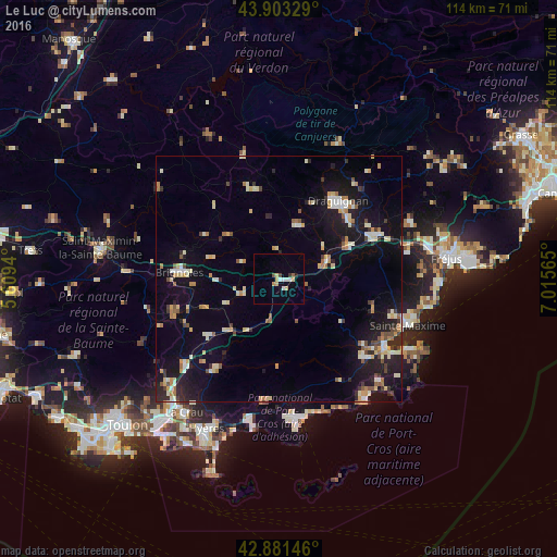
Analysis of Le Luc night lights 2016
Square area 10x10 km:
 1.9%
1.9%90-99
1.27%80-89
1.75%70-79
1.75%60-69
0.32%50-59
1.11%40-49
0.79%30-39
0.63%20-29
0%10-19
1.43%0-9
89.05%Square area 50x50 km:
0.72%90-99
1.94%80-89
1.53%70-79
1.16%60-69
1.14%50-59
1.06%40-49
0.8%30-39
1%20-29
2.09%10-19
9.48%0-9
79.08%Clear (daylight) street map image can be seen on geolist.org.
Map coordinates:
43° 54' 11.8" North, 5° 36' 33.8" East
43° 23' 40.3" North, 6° 18' 45.1" East
42° 52' 53.3" North, 7° 0' 56.3" East
Some cities around Le Luc sort by population:
• Draguignan
20 km =12.4 mi,  37°
37°
• Brignoles
20.3 km =12.6 mi,  273°
273°
• Le Muy
22.3 km =13.9 mi,  66°
66°
• Lorgues
11.7 km =7.3 mi,  19°
19°
• Vidauban
10.3 km =6.4 mi, 69°
• Les Arcs
15.4 km =9.6 mi,  60°
60°
• Garéoult
22.8 km =14.2 mi,  251°
251°
• Trans-en-Provence
18.5 km =11.5 mi,  49°
49°
3003650 (p: 7,953)
Sources (retrieved 2019-11-25):
» Earth at Night: Flat Maps 2012, 2016