Léognan night lights from space
Night Light of Léognan (Nouvelle-Aquitaine) from space (France) Src. Average luminocity for 10x10km area is 46.6394% and for 50x50km: 24.3002%.
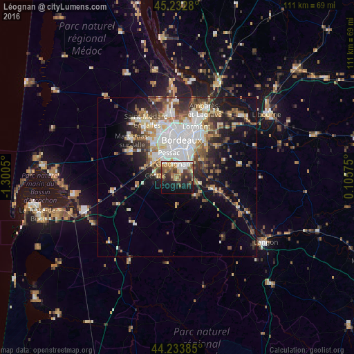
Analysis of Léognan night lights 2016
Square area 10x10 km:
 7.73%
7.73%90-99
7.58%80-89
5%70-79
8.03%60-69
7.27%50-59
7.58%40-49
6.67%30-39
8.94%20-29
11.36%10-19
21.06%0-9
8.79%Square area 50x50 km:
5.77%90-99
4.64%80-89
2.47%70-79
2.38%60-69
3.14%50-59
3.09%40-49
3.25%30-39
3.55%20-29
5.32%10-19
9.58%0-9
56.8%Clear (daylight) street map image can be seen on geolist.org.
Map coordinates:
45° 13' 58.1" North, 1° 18' 1.8" West
44° 44' 7.7" North, 0° 35' 50.6" West
44° 14' 1.9" North, 0° 6' 20.7" East
Some cities around Léognan sort by population:
• Mérignac
11.2 km =7 mi,  345°
345°
• Pessac
9 km =5.6 mi,  337°
337°
• Talence
7.7 km =4.8 mi,  1°
1°
• Villenave-d’Ornon
5.9 km =3.7 mi,  44°
44°
• Gradignan
4.3 km =2.7 mi, 342°
• Bègles
9 km =5.6 mi,  25°
25°
• Cestas
6.5 km =4 mi,  277°
277°
• Canéjan
4.5 km =2.8 mi,  320°
320°
3003067 (p: 8,890)
Sources (retrieved 2019-11-25):
» Earth at Night: Flat Maps 2012, 2016