La Cabucelle night lights from space
Night Light of La Cabucelle (Provence-Alpes-Côte d'Azur) from space (France) Src. Average luminocity for 10x10km area is 74.1762% and for 50x50km: 31.0434%.
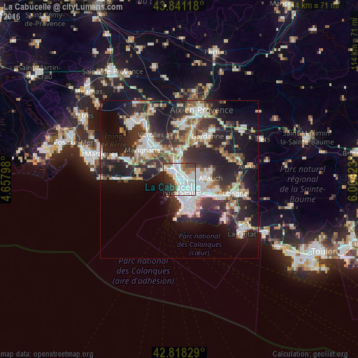
Analysis of La Cabucelle night lights 2016
Square area 10x10 km:
 39.21%
90-99
17.14%80-89
1.9%70-79
3.97%60-69
4.6%50-59
4.13%40-49
4.92%30-39
8.25%20-29
10%10-19
5.56%0-9
0.32%Square area 50x50 km:
6.84%90-99
6.64%80-89
3.12%70-79
2.51%60-69
2.98%50-59
3.4%40-49
3.49%30-39
6.01%20-29
11.66%10-19
16.36%0-9
36.98%Clear (daylight) street map image can be seen on geolist.org.
Map coordinates:
43° 50' 28.2" North, 4° 39' 28.7" East
43° 19' 54.8" North, 5° 21' 40" East
42° 49' 5.8" North, 6° 3' 51.2" East
Some cities around La Cabucelle sort by population:
• Marseille 14
2.1 km =1.3 mi,  47°
47°
• Saint-Mauront
2.2 km =1.4 mi,  147°
147°
• Bon-Secours
2.3 km =1.4 mi,  126°
126°
• Saint-Louis
1.9 km =1.2 mi,  343°
343°
• Le Canet
1.1 km =0.7 mi, 125°
• La Delorme
1.6 km =1 mi,  34°
34°
• Les Arnavaux
1.5 km =0.9 mi,  76°
76°
• Saint-Joseph
2.2 km =1.4 mi,  43°
43°
11919789 (p: 9,488)
Sources (retrieved 2019-11-25):
» Earth at Night: Flat Maps 2012, 2016