Bon-Secours night lights from space
Night Light of Bon-Secours (Provence-Alpes-Côte d'Azur) from space (France) Src. Average luminocity for 10x10km area is 85.8061% and for 50x50km: 29.9927%.
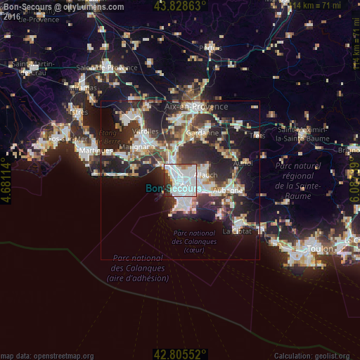
Analysis of Bon-Secours night lights 2016
Square area 10x10 km:
 53.64%
90-99
21.52%80-89
1.52%70-79
2.12%60-69
3.18%50-59
2.27%40-49
2.27%30-39
6.36%20-29
5.91%10-19
1.21%0-9
0%Square area 50x50 km:
6.73%90-99
6.57%80-89
3.03%70-79
2.36%60-69
2.85%50-59
3.12%40-49
3.28%30-39
5.68%20-29
10.99%10-19
15.75%0-9
39.65%Clear (daylight) street map image can be seen on geolist.org.
Map coordinates:
43° 49' 43.1" North, 4° 40' 52.1" East
43° 19' 9.2" North, 5° 23' 3.3" East
42° 48' 19.9" North, 6° 5' 14.6" East
Some cities around Bon-Secours sort by population:
• Saint-Just
1.8 km =1.1 mi,  98°
98°
• Belle de Mai
0.8 km =0.5 mi,  173°
173°
• Saint-Mauront
0.8 km =0.5 mi,  240°
240°
• Saint-Lazare
1.7 km =1.1 mi,  207°
207°
• Chutes-Lavie
1.3 km =0.8 mi,  140°
140°
• La Villette
1.2 km =0.7 mi,  225°
225°
• Le Canet
1.2 km =0.7 mi,  308°
308°
• Les Arnavaux
1.8 km =1.1 mi,  348°
348°
11919782 (p: 11,318)
Sources (retrieved 2019-11-25):
» Earth at Night: Flat Maps 2012, 2016