Issoire night lights from space
Night Light of Issoire (Auvergne-Rhône-Alpes) from space (France) Src. Average luminocity for 10x10km area is 15.8227% and for 50x50km: 4.0848%.
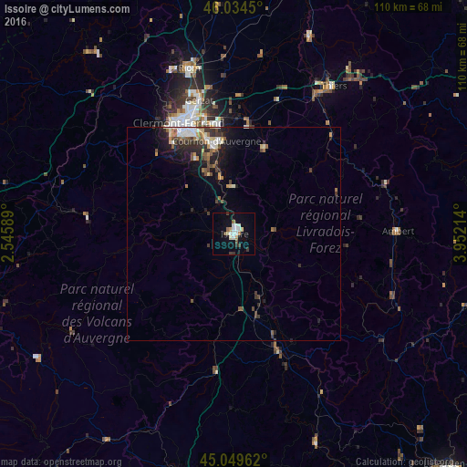
Analysis of Issoire night lights 2016
Square area 10x10 km:
 3.03%
3.03%90-99
3.48%80-89
1.36%70-79
0.61%60-69
1.67%50-59
1.06%40-49
2.27%30-39
1.67%20-29
0.61%10-19
8.94%0-9
75.3%Square area 50x50 km:
0.59%90-99
0.64%80-89
0.37%70-79
0.35%60-69
0.47%50-59
0.59%40-49
0.73%30-39
0.76%20-29
1.17%10-19
2.45%0-9
91.87%Clear (daylight) street map image can be seen on geolist.org.
Map coordinates:
46° 2' 4.2" North, 2° 32' 45.2" East
45° 32' 39.2" North, 3° 14' 56.4" East
45° 2' 58.6" North, 3° 57' 7.7" East
Some cities around Issoire sort by population:
• Clermont-Ferrand
29.1 km =18.1 mi,  334°
334°
• Cournon-d’Auvergne
22.3 km =13.9 mi,  349°
349°
• Beaumont
26.4 km =16.4 mi, 330°
• Aubière
25.4 km =15.8 mi, 334°
• Pont-du-Château
28.3 km =17.6 mi,  359°
359°
• Romagnat
23.6 km =14.7 mi, 330°
• Ceyrat
25.4 km =15.8 mi, 325°
• Le Cendre
20.4 km =12.7 mi, 346°
3012664 (p: 15,984)
Sources (retrieved 2019-11-25):
» Earth at Night: Flat Maps 2012, 2016