Fumel night lights from space
Night Light of Fumel (Nouvelle-Aquitaine) from space (France) Src. Average luminocity for 10x10km area is 8.8063% and for 50x50km: 1.7341%.
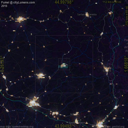
Analysis of Fumel night lights 2016
Square area 10x10 km:
 0.32%
0.32%90-99
0.95%80-89
0.63%70-79
0.16%60-69
2.86%50-59
2.06%40-49
2.22%30-39
0.95%20-29
4.44%10-19
0%0-9
85.4%Square area 50x50 km:
0.11%90-99
0.22%80-89
0.18%70-79
0.19%60-69
0.3%50-59
0.27%40-49
0.38%30-39
0.21%20-29
0.39%10-19
1.01%0-9
96.73%Clear (daylight) street map image can be seen on geolist.org.
Map coordinates:
44° 59' 52.7" North, 0° 15' 42.9" East
44° 29' 55" North, 0° 57' 54.2" East
43° 59' 41.8" North, 1° 40' 5.4" East
Some cities around Fumel sort by population:
• Agen
42.7 km =26.5 mi,  219°
219°
• Villeneuve-sur-Lot
23 km =14.3 mi,  244°
244°
• Cahors
37.8 km =23.5 mi,  98°
98°
• Sainte-Livrade-sur-Lot
31.7 km =19.7 mi,  249°
249°
• Bon-Encontre
42.1 km =26.2 mi,  214°
214°
• Gourdon
42.4 km =26.3 mi,  51°
51°
• Foulayronnes
38.4 km =23.9 mi, 221°
• Valence
43.8 km =27.2 mi,  187°
187°
3016903 (p: 5,816)
Sources (retrieved 2019-11-25):
» Earth at Night: Flat Maps 2012, 2016