Foix night lights from space
Night Light of Foix (Occitanie) from space (France) Src. Average luminocity for 10x10km area is 13.3556% and for 50x50km: 3.4233%.
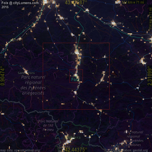
Analysis of Foix night lights 2016
Square area 10x10 km:
 0.63%
0.63%90-99
0.63%80-89
1.9%70-79
1.9%60-69
1.27%50-59
4.44%40-49
4.44%30-39
0.32%20-29
0.63%10-19
2.54%0-9
81.27%Square area 50x50 km:
0.08%90-99
0.33%80-89
0.24%70-79
0.39%60-69
0.57%50-59
0.92%40-49
0.84%30-39
0.68%20-29
0.72%10-19
1.67%0-9
93.57%Clear (daylight) street map image can be seen on geolist.org.
Map coordinates:
43° 28' 22.3" North, 0° 54' 17.1" East
42° 57' 37.7" North, 1° 36' 28.3" East
42° 26' 37.5" North, 2° 18' 39.6" East
Some cities around Foix sort by population:
• Pamiers
17.4 km =10.8 mi,  0°
0°
• Encamp, AD
47.4 km =29.5 mi,  182°
182°
• Lavelanet
19.7 km =12.2 mi,  99°
99°
• Auterive
44.7 km =27.8 mi,  346°
346°
• la Massana, AD
46.8 km =29.1 mi,  189°
189°
• Saint-Girons
37.7 km =23.4 mi,  274°
274°
• Canillo, AD
43.7 km =27.2 mi, 181°
• Ordino, AD
45.4 km =28.2 mi, 187°
3018174 (p: 9,860)
Sources (retrieved 2019-11-25):
» Earth at Night: Flat Maps 2012, 2016