Encamp night lights from space
Night Light of Encamp from space (Andorra) Src. Average luminocity for 10x10km area is 21.7825% and for 50x50km: 3.1981%.
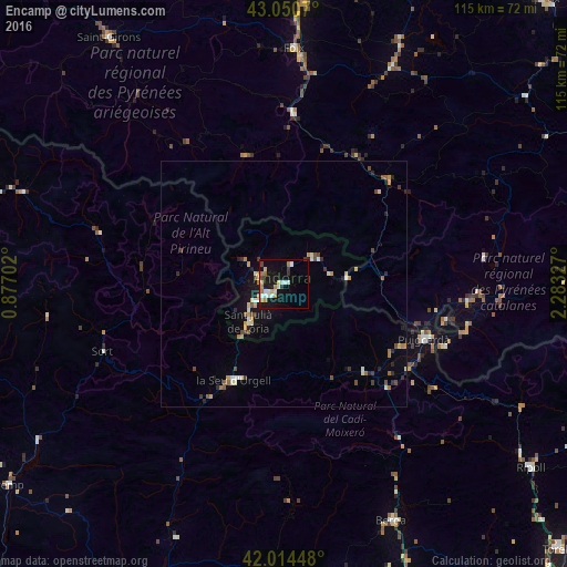
Analysis of Encamp night lights 2016
Square area 10x10 km:
 3.65%
3.65%90-99
4.29%80-89
2.86%70-79
3.33%60-69
3.33%50-59
0%40-49
1.59%30-39
2.06%20-29
0.79%10-19
22.38%0-9
55.71%Square area 50x50 km:
0.23%90-99
0.53%80-89
0.35%70-79
0.53%60-69
0.36%50-59
0.31%40-49
0.44%30-39
0.4%20-29
0.58%10-19
2.05%0-9
94.21%Clear (daylight) street map image can be seen on geolist.org.
Map coordinates:
43° 3' 2.5" North, 0° 52' 37.3" East
42° 32' 5.1" North, 1° 34' 48.5" East
42° 0' 52.1" North, 2° 16' 59.8" East
Some cities around Encamp sort by population:
• Andorra la Vella
5.7 km =3.5 mi,  238°
238°
• les Escaldes
4.9 km =3 mi,  231°
231°
• La Seu d'Urgell, ES
21.9 km =13.6 mi,  206°
206°
• Puigcerdà, ES
30.8 km =19.1 mi,  111°
111°
• Sant Julià de Lòria
10.7 km =6.6 mi,  222°
222°
• la Massana
5.5 km =3.4 mi,  282°
282°
• Canillo
3.9 km =2.4 mi,  21°
21°
• Ordino
4.5 km =2.8 mi,  301°
301°
3040686 (p: 11,223)
Sources (retrieved 2019-11-25):
» Earth at Night: Flat Maps 2012, 2016