Combourg night lights from space
Night Light of Combourg (Brittany) from space (France) Src. Average luminocity for 10x10km area is 1.1719% and for 50x50km: 2.1108%.
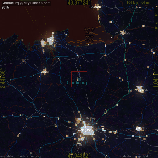
Analysis of Combourg night lights 2016
Square area 10x10 km:
 0%
0%90-99
0%80-89
0%70-79
0.57%60-69
0%50-59
0%40-49
0.14%30-39
1.14%20-29
0.99%10-19
0%0-9
97.16%Square area 50x50 km:
0.34%90-99
0.46%80-89
0.1%70-79
0.23%60-69
0.13%50-59
0.25%40-49
0.31%30-39
0.37%20-29
0.58%10-19
1.23%0-9
96%Clear (daylight) street map image can be seen on geolist.org.
Map coordinates:
48° 52' 38.1" North, 2° 26' 50.5" West
48° 24' 45.6" North, 1° 44' 39.3" West
47° 56' 37.8" North, 1° 2' 28" West
Some cities around Combourg sort by population:
• Dinan
23.1 km =14.4 mi,  281°
281°
• Betton
27 km =16.8 mi,  163°
163°
• Pacé
29.5 km =18.3 mi,  184°
184°
• Saint-Grégoire
29.4 km =18.3 mi,  171°
171°
• Liffré
28.2 km =17.5 mi,  141°
141°
• Cancale
30.3 km =18.8 mi,  344°
344°
• Melesse
22 km =13.7 mi, 170°
• Dol-de-Bretagne
15 km =9.3 mi,  358°
358°
3024137 (p: 5,362)
Sources (retrieved 2019-11-25):
» Earth at Night: Flat Maps 2012, 2016