Beauzelle night lights from space
Night Light of Beauzelle (Occitanie) from space (France) Src. Average luminocity for 10x10km area is 78.4545% and for 50x50km: 24.7351%.
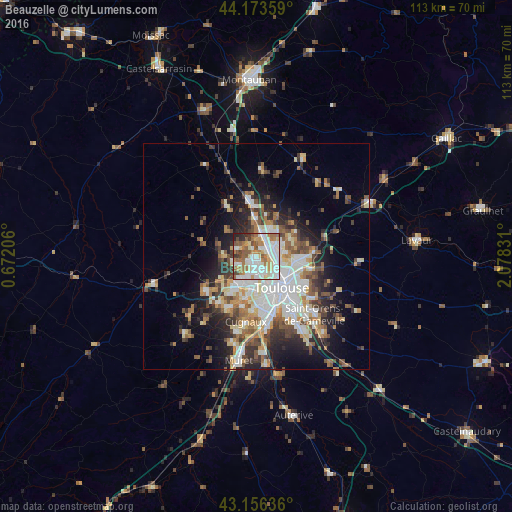
Analysis of Beauzelle night lights 2016
Square area 10x10 km:
 24.85%
90-99
22.73%80-89
7.88%70-79
7.73%60-69
13.33%50-59
11.21%40-49
4.55%30-39
3.64%20-29
3.79%10-19
0.3%0-9
0%Square area 50x50 km:
5.08%90-99
5.33%80-89
2.77%70-79
2.43%60-69
3.22%50-59
3.29%40-49
3.59%30-39
3.4%20-29
5.43%10-19
8.54%0-9
56.93%Clear (daylight) street map image can be seen on geolist.org.
Map coordinates:
44° 10' 24.9" North, 0° 40' 19.4" East
43° 40' 1.7" North, 1° 22' 30.6" East
43° 9' 22.9" North, 2° 4' 41.9" East
Some cities around Beauzelle sort by population:
• Colomiers
7.1 km =4.4 mi,  207°
207°
• Blagnac
4.1 km =2.5 mi,  158°
158°
• L'Union
8.7 km =5.4 mi,  94°
94°
• Castelginest
5.6 km =3.5 mi,  58°
58°
• Aucamville
4.3 km =2.7 mi, 85°
• Launaguet
6.6 km =4.1 mi,  79°
79°
• Saint-Alban
4 km =2.5 mi,  44°
44°
• Cornebarrieu
4.6 km =2.9 mi,  243°
243°
3033953 (p: 6,043)
Sources (retrieved 2019-11-25):
» Earth at Night: Flat Maps 2012, 2016