Gignac-la-Nerthe night lights from space
Night Light of Gignac-la-Nerthe (Provence-Alpes-Côte d'Azur) from space (France) Src. Average luminocity for 10x10km area is 61.4413% and for 50x50km: 32.9043%.
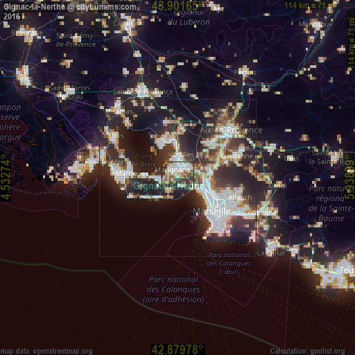
Analysis of Gignac-la-Nerthe night lights 2016
Square area 10x10 km:
 12.38%
90-99
15.71%80-89
7.62%70-79
7.46%60-69
4.92%50-59
11.59%40-49
6.19%30-39
15.4%20-29
15.08%10-19
3.65%0-9
0%Square area 50x50 km:
7.31%90-99
7.14%80-89
3.15%70-79
2.68%60-69
2.77%50-59
3.79%40-49
3.63%30-39
6.22%20-29
13.49%10-19
17.01%0-9
32.79%Clear (daylight) street map image can be seen on geolist.org.
Map coordinates:
43° 54' 5.9" North, 4° 31' 57.9" East
43° 23' 34.3" North, 5° 14' 9.1" East
42° 52' 47.2" North, 5° 56' 20.4" East
Some cities around Gignac-la-Nerthe sort by population:
• Vitrolles
7.5 km =4.7 mi,  7°
7°
• Marignane
3.2 km =2 mi,  327°
327°
• Les Pennes-Mirabeau
6.2 km =3.9 mi,  71°
71°
• Marseille 16
8.8 km =5.5 mi,  114°
114°
• Châteauneuf-les-Martigues
5.9 km =3.7 mi,  260°
260°
• Saint-Victoret
3 km =1.9 mi,  357°
357°
• L'Estaque
6.7 km =4.2 mi,  118°
118°
• Saint-Henri
8.4 km =5.2 mi, 114°
3016070 (p: 9,146)
Sources (retrieved 2019-11-25):
» Earth at Night: Flat Maps 2012, 2016