Behren-lès-Forbach night lights from space
Night Light of Behren-lès-Forbach (Grand Est) from space (France) Src. Average luminocity for 10x10km area is 45.9762% and for 50x50km: 21.2557%.
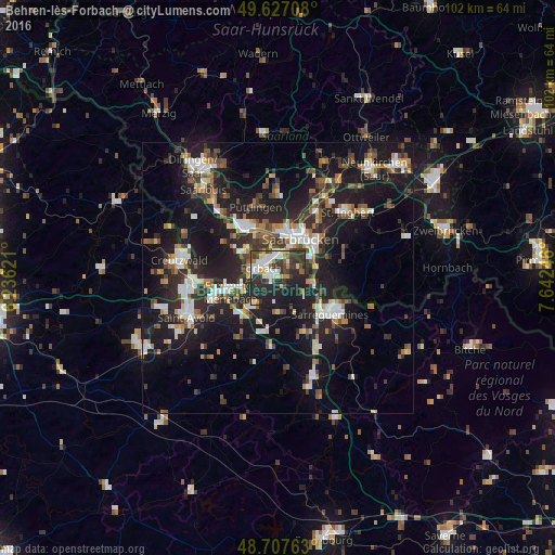
Analysis of Behren-lès-Forbach night lights 2016
Square area 10x10 km:
 8.26%
8.26%90-99
11.2%80-89
4.34%70-79
4.34%60-69
2.8%50-59
3.78%40-49
4.76%30-39
14.43%20-29
25.07%10-19
21.01%0-9
0%Square area 50x50 km:
3.18%90-99
3.38%80-89
1.6%70-79
1.91%60-69
2.48%50-59
2.68%40-49
3.18%30-39
3.77%20-29
8.84%10-19
20.69%0-9
48.28%Clear (daylight) street map image can be seen on geolist.org.
Map coordinates:
49° 37' 37.5" North, 6° 14' 10.4" East
49° 10' 10.2" North, 6° 56' 21.6" East
48° 42' 27.5" North, 7° 38' 32.9" East
Some cities around Behren-lès-Forbach sort by population:
• Saarbrücken, DE
8.7 km =5.4 mi,  36°
36°
• Völklingen, DE
10.8 km =6.7 mi,  327°
327°
• Forbach
4 km =2.5 mi,  301°
301°
• Stiring-Wendel
3.7 km =2.3 mi,  351°
351°
• Kleinblittersdorf, DE
7.2 km =4.5 mi,  100°
100°
• Großrosseln, DE
8 km =5 mi, 297°
• Farébersviller
7.6 km =4.7 mi,  222°
222°
• Petite-Rosselle
7.7 km =4.8 mi,  307°
307°
3033853 (p: 10,225)
Sources (retrieved 2019-11-25):
» Earth at Night: Flat Maps 2012, 2016