Bazas night lights from space
Night Light of Bazas (Nouvelle-Aquitaine) from space (France) Src. Average luminocity for 10x10km area is 5.1476% and for 50x50km: 2.6275%.
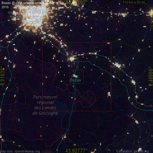
Analysis of Bazas night lights 2016
Square area 10x10 km:
 0%
0%90-99
0.63%80-89
1.9%70-79
0%60-69
1.43%50-59
1.11%40-49
0%30-39
0.63%20-29
1.27%10-19
0%0-9
93.02%Square area 50x50 km:
0.14%90-99
0.3%80-89
0.13%70-79
0.22%60-69
0.47%50-59
0.65%40-49
0.56%30-39
0.53%20-29
0.65%10-19
0.89%0-9
95.46%Clear (daylight) street map image can be seen on geolist.org.
Map coordinates:
44° 55' 55" North, 0° 54' 59" West
44° 25' 55.3" North, 0° 12' 47.8" West
43° 55' 40" North, 0° 29' 23.5" East
Some cities around Bazas sort by population:
• Villenave-d’Ornon
46.1 km =28.6 mi,  325°
325°
• Gradignan
49.4 km =30.7 mi,  320°
320°
• Bègles
49.5 km =30.8 mi, 327°
• Marmande
31 km =19.3 mi,  75°
75°
• Tonneins
42 km =26.1 mi,  96°
96°
• Léognan
45.4 km =28.2 mi, 317°
• Langon
13.8 km =8.6 mi,  347°
347°
• Casteljaloux
27 km =16.8 mi,  118°
118°
3034458 (p: 5,131)
Sources (retrieved 2019-11-25):
» Earth at Night: Flat Maps 2012, 2016