Altkirch night lights from space
Night Light of Altkirch (Grand Est) from space (France) Src. Average luminocity for 10x10km area is 19.4211% and for 50x50km: 17.6343%.
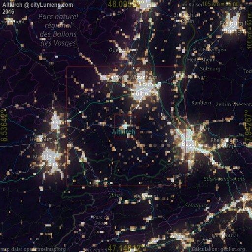
Analysis of Altkirch night lights 2016
Square area 10x10 km:
 1.49%
1.49%90-99
2.98%80-89
0.89%70-79
2.08%60-69
1.19%50-59
4.91%40-49
1.93%30-39
3.27%20-29
3.57%10-19
29.32%0-9
48.36%Square area 50x50 km:
2.75%90-99
2.74%80-89
1.45%70-79
1.78%60-69
1.71%50-59
2.54%40-49
2.48%30-39
3.13%20-29
5.18%10-19
13.65%0-9
62.58%Clear (daylight) street map image can be seen on geolist.org.
Map coordinates:
48° 5' 45.3" North, 6° 32' 11.1" East
47° 37' 27" North, 7° 14' 22.3" East
47° 8' 53.2" North, 7° 56' 33.6" East
Some cities around Altkirch sort by population:
• Mulhouse
15.7 km =9.8 mi,  25°
25°
• Illzach
18.7 km =11.6 mi, 26°
• Rixheim
18.5 km =11.5 mi,  41°
41°
• Riedisheim
16.8 km =10.4 mi, 34°
• Kingersheim
19.7 km =12.2 mi,  19°
19°
• Pfastatt
16.8 km =10.4 mi, 16°
• Lutterbach
15.4 km =9.6 mi,  11°
11°
• Brunstatt
12.4 km =7.7 mi, 29°
3038012 (p: 5,564)
Sources (retrieved 2019-11-25):
» Earth at Night: Flat Maps 2012, 2016